Western Uganda Guide


Karegyeya Rock

The Karegyeya Rock, known locally as Eibare rya Karegyeya, can be found just over a mile outside of Ntungamo in Karegyeya village on the road to the two street hilltop town of Rukungiri. The formation of the rock is rooted deep within the Precambrian basement complex that forms the bedrock of much of East Africa. It's a story told over hundreds of millions of years, beginning with the slow crystallisation of magma deep beneath the Earth’s surface, resulting in the characteristic rugged texture of granite and related gneissic formations. This intense, durable rock was then subjected to the relentless forces of erosion and tectonic uplift. Over geological epochs, the softer surrounding sediments were worn away by wind and rain, processes that gradually exposed the more resistant core, leaving Karegyeya Rock as an inselberg, a mountain island isolated on a plain.

This sculpting by millennia of weathering has given the rock its distinctive, somewhat precarious shape, a jagged dome that seems almost impossible for nature to have so perfectly balanced, providing a constant reminder of the immense, slow-motion violence of planetary forces. The legend of the rock encompasses local traditions of the ancient Bachwezi (see image below); demi-gods who took on human form but did not die, instead disappearing into the underworld. They were said to be the original, traditional rulers of the empire of Kitara, a probably mythical kingdom that existed in the 14th and 15th centuries and covered parts of modern-day Uganda (including Ntungamo), Tanzania, DRC, Kenya, Rwanda and Burundi. The Bachwezi were in turn, believed to be related to the Batembuzi, a dynasty founded by Ruhanga, the creator. The last of the Batembuzi rulers, Isaza, is believed in tradition to have married and had a child with Nyamata, the daughter of the king of the underworld, Nyamiyonga. Nyamiyonga was later to seek vengeance on King Isaza for attempting to deceive him over a pact and lured him into the underworld from where he was never to return to the world of men.

The Karegyeya Rock is believed locally to form an entrance to this underworld and that the Bachwezi still reside down there, a legend perpetuated by rumours of fires seen at night emanating from the rocks with ashes and worldly goods scattered around them at day break. In order to keep the locals away and to prevent them from exploring the secrets of Karegyeya Rock further, a further legend of a giant snake that lurks under the rock also exists. A snake so large, its belly contains a massive lake that if the rock were ever destroyed, the waters would break free and devastate the surrounding areas like a dam breaking.

Other legends connect the rock to a tale of bravery, tragedy, and the harsh realities of survival. One prevalent version recounts the story of a renowned warrior or shepherd who, cornered by enemies or faced with a desperate situation, perhaps a famine or a severe drought, made a dramatic stand or even a sacrificial act near or upon the rock. Another popular retelling speaks of the ancient practice where individuals facing insurmountable societal challenges or seeking powerful divination would climb the rock, believing the altitude brought them closer to ancestral spirits or the divine. The name itself is often interpreted to relate to a ‘great fall’ or a ‘challenging climb,’ cementing the rock’s reputation not just as a landmark, but as a place where life-altering decisions were once made, embedding a sense of awe and spiritual reverence into its landscape.


Karegyeya Rock

Karegyeya Rock

Karegyeya Rock

Karegyeya Rock


Hot Springs

Ugandan Hot Springs

The Kitagata or Mulago (meaning 'hospital') Hot Springs are believed locally to have healing powers.
More >


Bachwezi Demi-Gods

Karegyeya Rock

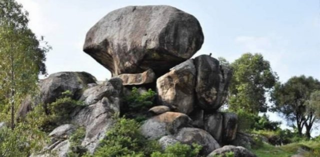
For the local Banyankole people, particularly the clans that have grazed their cattle there for centuries, regardless of the legends, Karegyeya Rock is a living archive, a natural feature that provided essential strategic advantages and served as a focal point for communal life. Historically, its height made it an unparalleled natural observatory, allowing shepherds to scan the horizon for lost herds or, more crucially, for approaching enemies during periods of inter-clan conflict. Because of its visibility, it became integrated into traditional wayfinding and ritual, a fixed point of reference in a world that relied heavily on oral tradition and natural signs for navigation and survival across the sprawling Ankole Kingdom.

Today, the history of Karegyeya Rock remains largely confined to oral traditions passed down through generations of local elders. Official historical documentation by state archives or detailed archaeological surveying is sparse, meaning that visitors and researchers must rely heavily on local guides and community custodians who maintain these stories. This reliance on oral history is both a blessing and a burden; it keeps the tradition vibrant and localised but also exposes the site to the risk of fragmented or lost narratives over time, especially as younger generations migrate away from traditional areas. Effort is now being made by local tourism bodies and cultural advocates to systematically record these stories, recognising Karegyeya Rock not just as a tourist attraction, but as a critical piece of Uganda's intangible cultural heritage.

What is verifiably known is that Karegyeya Rock played a role in the political and military history of the region. During the zenith of the pre-colonial Ankole Kingdom, the area around Ntungamo served as a borderland, frequently contested by neighbouring polities. Karegyeya Rock functioned as an ideal military lookout, a vantage point from which messengers could warn local settlements of incursions. Later, during the turbulent colonial period and the subsequent years of civil unrest in Uganda, the strategic importance of the high ground did not diminish. It is widely acknowledged that during the National Resistance Army (NRA) struggle that brought Yoweri Museveni to power in the 1980s, geographical features like Karegyeya were vital for reconnaissance and supply route monitoring, providing a critical operational advantage to those who controlled its summit, thus linking the ancient military uses of the rock directly to modern political history.

If visiting, be mindful that the ascent itself is demanding, a scramble up steep, sometimes slick granite surfaces. However, the reward for this effort is breathtaking: a vast, sweeping panorama of Ntungamo District, showcasing the fertile valleys, scattered homesteads, and the distant, silver ribbon of the River Kagera slicing through the landscape. Now check out our Karegyeya Rock video and map.


Tourist
Attractions

Western Uganda Tourist Attractions


Best Things
To Do

Things to do in Western Uganda Guide


Main Ugandan
Towns

Main Ugandan Towns


Western Uganda
Accommodation

Accommodation in Western Uganda Guide