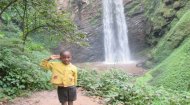
Western Uganda Guide


Wambabya Falls

The River Wambabya, stretching 68.5 kilometres through Hoima District and feeding into Lake Albert, is home to the often overlooked, but nonetheless impressive Wambabya Falls. This cascading waterfall, with its roaring torrents and mist-laden air, has long captivated the imaginations of travellers, researchers, and locals alike. Known locally as 'Wambabya,' which translates to 'Place of Rocks' in the Luganda language, the falls have a history interwoven with the traditions of the indigenous communities that have inhabited the area for centuries. While the falls may lack the grand historical narratives of ancient kingdoms or colonial conflicts, their presence on maps and in oral histories speaks to their enduring role as a landmark. Local folklore often describes the waterfall as a sacred site, believed to be the dwelling of ancestral spirits or deities who govern the fertility of the land.

In some communities, the falls are also known as 'Mbuya’s Tears,' a reference to a legendary figure said to have wept for her kin after a great migration, but are more commonly known as the Kikonko Falls, a reference to the area surrounding the well-known Kikonko Lodge, a tourist destination near Lake Albert. Such alternative names, born from myth and memory, underscore the emotional and spiritual ties that bind the people to the fall's natural marvel. At the heart of Wambabya Falls lies a geological spectacle. The river, driven by the force of gravity and the gradient of the terrain, plunges approximately 30 meters in a single drop, creating a powerful and mesmerising cascade.

The cultural significance of Wambabya Falls extends beyond its physical allure. For the Batuku and neighbouring communities, it is a site of collective identity and pride. Traditional rituals and ceremonies are often held near the falls, especially during times of drought or harvest, as the water is seen as a symbol of abundance and renewal. These practices, though sometimes adapted to modern influences, remain a vital part of the region’s intangible heritage. Additionally, the falls have inspired local art and music, with melodies and carvings that echo the rhythms of the cascading water. The name itself, “Wambabya,” serves as a reminder of the community’s resilience and adaptability, much like the river that sustains them. However, the area’s cultural value has not always been fully recognised on a national or global scale, and efforts to archive oral histories and integrate them into formal tourism narratives are ongoing.

The height of the falls is not merely a statistic but a defining feature that influences the ecosystem and human interaction with the site. The sheer energy of the water as it strikes the bedrock below generates a mist that sustains the dense vegetation in the vicinity, fostering a microhabitat teeming with life. This unique environment supports a variety of flora, including ferns, mosses, and towering trees whose roots grip the rocky slopes. For visitors, the falls are a source of awe and a hub of activity, offering opportunities for swimming in the cool, inviting pools at the base, hiking along the rugged trails that lead to panoramic viewpoints, and capturing breathtaking photographs of the water’s fury or the gentle dawn mist that shrouds the scene.


Wambabya Falls

Wambabya Falls

Wambabya Falls

Wambabya Falls


Kibiro Hot Springs

Kibiro Hot Springs

A guide to the Kibiro Salt Gardens and Hot Springs including their history and alleged healing properties.
More >


Wambabya Falls

Wambabya Falls Guide

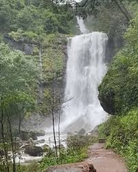
While Wambabya Falls is a relatively lesser-known destination compared to Uganda’s more iconic attractions like Murchison Falls or the Bwindi Impenetrable Forest, it holds its own in terms of ecological and recreational appeal. The surrounding area is part of a broader network of waterways and wetlands, which contribute to the hydrological balance of the region, with the nearby Kabalega Hydroelectric Power Station being located in Buseruka Village, close to the eastern shores of Lake Albert.

Conservation efforts have become a cornerstone of preserving Wambabya Falls and its ecosystem. The Uganda Wildlife Authority, along with non-governmental organisations and local cooperatives, have implemented measures to prevent erosion, monitor water quality, and educate visitors on minimising their environmental impact. These initiatives are critical in combating threats such as deforestation, pollution, and unregulated tourism, which risk disrupting the delicate balance of the area’s biodiversity. The surrounding forests and wetlands, including the Wambabya Central Forest Reserve, are home to a myriad of species, including the endangered chimpanzee, various bird species like the crowned eagle, the African Fish Eagle, the Shoebill Stork (often seen in nearby Mabamba Swamp), Kingfishers, Weavers (like the Papyrus Gonolek), Sunbirds, and Cranes. Visitors can also spot a host of amphibians and reptiles, including the Golden Puddle Frog and Kivu Clawed Frog, together with Duke of Abruzzi’s, silver and Mongalia Free-tailed bats (a species of conservation concern), as well as plant species including Mutuba trees

For those planning a visit to Wambabya Falls, which are often visited together with the Kabalega Hydropower station, take a vehicle from Hpima itself heading west toward Buseruka Sub-County, where River Wambabya and the falls are located. Please note, there is no formal signposted tourist route, but follow the main Hoima–Buseruka road (mostly tarmac/murram depending on conditions) until reaching local villages and junctions near Wambabya or nearby forestry areas. From there, a local guide, boda-boda (motorcycle taxi), or 4×4 vehicle can take you on the final leg to where the cascades are visible (often 2–5 km off the main road, depending on rainy-season water levels). If you don’t have access to your own car, you can hire a private taxi or take a boda-boda from Hoima to Buseruka/Wambabya locality and then to the river site. Local drivers often know the rough access points to Wambabya Falls and the scenic spots along the river where the water cascades over the escarpment. Please note, roads beyond Hoima can become rough or muddy in rainy seasons, so a 4×4 or robust vehicle is recommended.
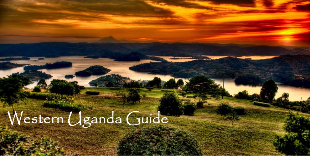


Tourist
Attractions

Western Uganda Tourist Attractions


Best Things
To Do

Things to do in Western Uganda Guide


Main Ugandan
Towns

Main Ugandan Towns


Western Uganda
Accommodation

Accommodation in Western Uganda Guide